Showing posts with label hiking. Show all posts

Tuesday, June 2, 2009

Dune walk

While at Zion we spent one day camping at the Coral Pink Sand Dunes State Park. Camping was ok and hike was fun. Josh and Morgan went to hike the Narrows this day and the rest of us opted out and spent some time playing in the sand.

Coral Pink Sand Dunes, Utah


She'll pump YOU up

Resting in the sand

Playing in the sand

Monday, June 1, 2009

ZION

Leaving Harmony Hills we headed to Utah to meet my friend Sarah Jane and a friend of hers for a backpacking trip in Zion National Park.  Memorial day weekend and we have made no reservations... uh oh.  It turn out even though we were not able to do the multi-day backpacking trip we had hoped for. We ended up doing an overnight trip up the East Rim Trail to Cable Mountain. Had a great time. It was our maiden backpacking trip and a great location to begin our backpacking future. Seeing my friend Sarah Jane was awesome and she and Charly got along amazingly. We learned a lot about how to load our packs and what kind of things to bring along. 

I have to admit when we first arrived in Zion I was disappointed. After being at the Grand Canyon it seemed to be lacking in grandeur. It didn't take my breath away. However as we hiked and camped my appreciation grew. Zion has so much to offer such as climbing, hiking, camping, and sight seeing. You can approach the park in multiple ways and have a good variety of activities to choose from. Once we started hiking through the different areas of the canyon I found the lack of grandeur replaced by the intimate beauty of slot canyons and massive sandstone walls.  

Zion National Park in Utah

The hiking crew

Shiny Canyon

Sandstone monoliths abound


Polygamy Porter, a delicious porter... why have just one

Backpacking trip

Sarah Jane lifts a boulder

Super hikers

Charly shows us what it would look like if she bit the head off of a chipmunk

Morgan and Josh catch some shade

Morgan

Charly and Sarah Jane posing

Backpacking up the East Rim Trail


Today's hike is behind us... Angels Landing.

Sarah Jane if front of Angels Landing

Walter's Wiggles take you up

Yep we started way down there


We made it to the top!

We are crazy kids. A lady walked by and told us we were giving our mother's a heart attack.

Charly at Kolab
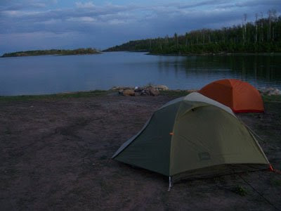
Camped up in Kolab one night

Bighorn

Angels Landing Bhudda

US

Saturday, April 11, 2009

THE FLATIRON

...Or as we say, "The Flairtron" (an early error of pronunciation that stuck). To reach the Flatiron we take the Siphon Draw trail which is 1.8 miles from the trailhead to the top of the Flatiron. We start at an elevation of about 2160 ft and  end at 4,861 ft that's a 2,701 ft elevation gain in less then 2 miles. Challenging and fun!

We are heading way up there

Hiking up the trail (I'm wearing a new hat Charly made me!)

Rest time

Ahhh shade

Long way up here

Long way left to go

At the top

Collared lizard we found at the top.

Resting on a rock

Wow

At the top looking down at the trail head

Holy crap! We have to go all the way back down there?!

Climbing down

Beautiful Day

Monday, March 23, 2009

Challenge and Satisfaction

Challenging our hiking skills, we set out to hike the Peralta trail once again. This time we made a loop taking the lesser travelled, unmarked Cave trail down from the Fremont Saddle point of the Peralta trail. After reaching the saddle, we headed to the Weaver's Needle overlook. From there we caught the Cave trail which would take us down the ridge opposite the one we climbed up. 

ARRRGH! We made it to Weaver's Needle overlook!

A hottie at Weaver's Needle overlook

Can you find the profile of a head of rock in this photo.

In this picture we are on the Peralta trail looking up at the caves (2 dark spots just above the yellowish layer of rock) on the Cave Trail.

The challenge of Cave trial resides in the many tributaries branching off to the other side of the ridge, backward, or nowhere. Many times the trail disappears and all you have is a jumble of boulders. It is on this hike we learned the importance of cairns. The dictionary entry is as follows: cairn |ke(ə)rn| noun 1) a mound of rough stones built as a memorial or landmark, typically on a hilltop or skyline.  When the trial was just a large face of a giant boulder cairns showed the way. 

Charly teaches about cairns

As we hiked along the trail we could look down and see people on the Peralta trail.

Soon we came to the fortress a large hill where just up past the yellow layer of rocks are the caves we heading for. We eventually reach the caves do some exploring. Then set out to begin the most treacherous part of the hike. We will soon reach Devils Slide and then traverse down a boulder sliding down 20 feet on out butts.  Once we reached the bottom we continued to Cathedral Rock looking back we could see our accomplishment. Satisfaction, a beautiful day and a wonderful hike full of adventure. 
 
The Fortress

View of Cathedral Rock from the Fortress

Exploring the caves

Cutie in a cave

View of Peralta Trail from caves

Looking back at where we've been